
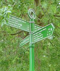
 Introducing the Green Chain Walk
The South East London Green Chain is made up of over 300 open spaces and woodland that form a great arc of undeveloped land between the River Thames and Crystal Palace Park. The 52 mile Green Chain Walk (GCW) was established and waymarked in 1977 to ease and encourage the exploration of this unique resource. The footpath is a branching network of 15 + 1 sections which offer many opportunities for circular and linear walks. You will find it helpful to download our concise introduction to the network with a map showing all the sections. (The longest of the 'proposed' sections on the map is section 12 - the +1 section. The GCW news page has a map showing section 12 more clearly.)
The topography of the network is so interesting that we have also created a relief map for you to download to see how the sections rise and fall with the hills and valleys of the area.
Download your free walk guidance here
Click on the title of a section, in the table below, to download the pdf file of walk guidance. Note that the distances in the table do not include walking from the nearest station or bus stop to the start and finish of each walk.
During 2022-23, Ramblers' volunteers wrote the text of these walk guides, devised the maps and researched the details for all sections of the Green Chain Walk.
Note that we have included section 12 in the table below. This extra section was part of the original plan but was never established so there is no waymarking. However it is a very enjoyable walk with a spectacular ending. Our guidance makes it practicable to walk this section that is largely off-road.
The latest information about toilets and other facilities
Click this link to download a file that gives more detail about the facilities along the sections of the Green Chain Walk than in our walk guidance. Information about toilets, sources of refreshment and places to sit and rest changes more rapidly than the walking route itself. This separate document allows us to update the details more rapidly.
Green Chain Walk news page
Ramblers volunteers monitor all sections of the Green Chain Walk with the aim of ensuring that they are properly maintained and improved for the public to enjoy. We report any short term changes that make it difficult to walk any of the sections on the news page for the Green Chain.
Give us your feedback - please
Please
| Section (click to download pdf) | Distance | Transport to start | Transport from end | |
|---|---|---|---|---|
| 1 | Thamesmead to Lesnes Abbey | 2.5 or 2.75 miles |
Bus from Abbey Wood, Woolwich or Plumstead stations |
Bus or walk to Abbey Wood station |
| 2 | Erith to Bostall Heath | 3.5 miles | Bus or walk from Erith station | Bus to Abbey Wood, Woolwich or Plumstead stations |
| 3 | Bostall Heath to Oxleas Meadow | 3.8 miles | Bus from Abbey Wood, Woolwich or Plumstead stations |
Falconwood or bus to other stations |
| 4 | Bostall Heath to Charlton Park | 3.6 miles | Bus from Abbey Wood, Woolwich or Plumstead stations |
Charlton or bus to other stations |
| 4a | Plumstead Common to Oxleas Meadow | 1.8 miles | Bus or walk from Plumstead station | Falconwood or bus to other stations |
| 5 | Thames Barrier to Oxleas Meadow | 4 miles | Charlton or bus from other stations |
Falconwood or bus to other stations |
| 6 | Oxleas Wood to Mottingham Lane | 3.9 miles | Falconwood station | Mottingham station |
| 7 | Shepherdleas Wood to Middle Park | 4.3 miles | Falconwood station | Mottingham station |
| 8 | Mottingham Lane to Stumps Hill (Beckenham Place Park) | 4.8 miles | Mottingham station | Beckenham Hill or Beckenham Junction stations or tram |
| 8a | Marvels Lane to Elmstead Wood | 0.9 miles | Grove Park station | Grove Park station |
| 9 | Mottingham Lane to Beckenham Place Park | 6.2 miles | Mottingham station | Beckenham Hill or Beckenham Junction stations or tram |
| 9a | Elmstead Wood to Chislehurst | 1.7 miles | Mottingham or Grove Park stations | Bus or walk to Chislehurst station or bus to other stations |
| 10 | Stumps Hill (Beckenham Place Park) to Crystal Palace | 3.7 miles | Beckenham Hill or Beckenham Junction stations or tram | Crystal Palace station |
| 11 | Nunhead to Crystal Palace | 5.9 miles | Nunhead or Brockley stations | Crystal Palace station or bus |
| 11a | Dulwich Park to Sydenham Hill Wood | 1.3 miles | West Dulwich station or bus | Sydenham Hill station or bus |
| 12 | Eltham to Greenwich (not waymarked) | 5.5 miles | Mottingham or Eltham stations | DLR Cutty Sark or Greenwich mainline stations |