
This linear walk of 5.13 miles (8.26 kilometres) links a number of green spaces within the heavily built-up area of Islington and Hackney boroughs. Many of Islington's streets and squares have beautiful Georgian terraces; the end of the walk links a fine park with a thickly-wooded cemetery in the centre of busy Stoke Newington.
1. Leave Angel tube station and turn left for 80 metres to the main crossroads, where turn left again down City Road for a further 130 metres to enter Duncan Terrace Gardens on the left.
The area takes its name from a coaching inn that stood at the crossroads; the present Angel pub is at a slightly different location. The gardens between Duncan Terrace and Colebrook Row cover the course of the New River, an artificial water supply from Hertfordshire to London, completed in 1613 and covered over here in 1861. Both these streets have fine Georgian terraces.
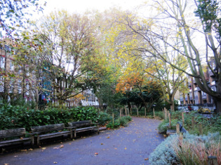
Duncan Terrace Gardens
2. Cross over Duncan Street and continue through a second section of the gardens, at the end continuing to walk along Colebrooke Row. A diversion to the famous Camden Passage Antiques Market (open Wednesdays and Saturdays) can be made by turning left up Charlton Place, later returning to this point. Otherwise continue along Colebrooke Row. At No 64, on the left by Bridel Mews, lived the essayist, Charles Lamb. The road now swings left and right, crossing St Peter's Street. In another 50 metres, walk a few paces left to gain Essex Road, where turn right.
3. Use the light-controlled crossing to arrive at St Mary's Path by the Kings public house and turn left. Where the road bends, enter St Mary's Church Garden. Go up the steps behind the church and leave the gardens by the gate on the right by the Little Angel Theatre.
St Mary's Church was built in 1751-4. The body of the church was destroyed in the war, although the tower and spire survived. The replacement church dates from 1954-6. The Little Angel Theatre, styled as the Home of British Puppetry, has been on this site since 1961.
4. Turn left along Dagmar Passage then right upon reaching Cross Street, noting the fine row of houses with elaborate door-cases on the right. Just after the Baptist Church, turn left into Halton Road, then right into Halton Cross Street. Cross Pleasant Place and turn left into Astey's Row Rock Garden, later continuing into the section with the playground, finally leaving by a gate on the right at the far end.
5. Cross over Canonbury Road and walk a few paces down Canonbury Grove to enter the New River Walk on the left. Follow the waterside path, past an old brick watch hut, to where it emerges by the Marquess Tavern, built in 1848. Turn left for 20 metres up a short section of Willow Bridge Road, then right into the continuation of the gardens parallel with Douglas Road and Islay Walk. The gardens eventually emerge onto St Paul's Road, where turn left.

New River Walk
Drop-out point: If you want to leave the walk at this point, Canonbury Overground Station is 150 metres along Wallace Road opposite the exit from the gardens.
6. Turn left after 25 metres and walk along Canonbury Park South - the poet, Louis MacNeice lived at No 52. At its end, go forward into Canonbury Place, dominated by the late 16th-century Canonbury Tower. It is worth taking a few steps left beyond the Tower into Alwyn Villas to admire the fine Canonbury House, rebuilt circa 1770; turning left again into the cul-de-sac will bring you to a board explaining the history of the Tower and House. Note also the building on the corner where lived Sir Basil Spence, the architect of the new Coventry Cathedral.
7. Returning to the junction, maintain your previous direction by going forward into Canonbury Square, turning left and then right to walk through the gardens, carefully crossing Canonbury Road to continue through a second garden.
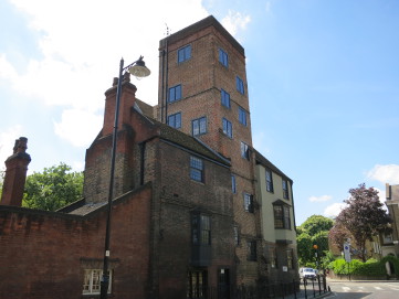 Canonbury Tower |
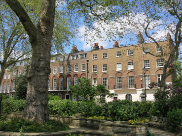 Canonbury Square |
8. Ahead now into Canonbury Lane, crossing Compton Avenue, then just before reaching Upper Street, turn right through the gardens alongside Compton Terrace, a fine late-Georgian street, somewhat marred by the disproportionally-sized Union Chapel of 1876, past where the gardens continue for a few paces. Exit on the right and go down a flight of steps.
9. We have now arrived at Highbury Corner. There is a good selection of shops and pubs from which to buy refreshments. Go half-left to take the pedestrian crossing, then bear right to arrive at Highbury and Islington Station, opposite which go over a second crossing and forward into Highbury Place.
10. Go past the memorial in art nouveau style commemorating the Boer War - the painter, Walter Sickert had a studio on the right - continue forward on the broad pavement, passing Highbury Leisure Centre on the left. Where the railings end, go half-left on an unsurfaced path across grass, through an avenue of trees and onwards. This is now Highbury Fields; at 11.75 hectares (29 acres), it is the largest open space in the Borough of Islington.
11. At the top-left corner, opposite the end of Ronalds Road, walk forward alongside another section of the Fields, close-by Highbury Terrace on the left. These fine houses were built from 1789 onwards. On reaching a cross-path - opposite No 13 - turn right, soon crossing a cycle track, then continue past a café and tennis courts.
12. Leave the Fields to cross Highbury Grove and enter Aberdeen Park opposite. This private estate, first laid out in 1853, has a refreshing lack of yellow lines and parking meters, although parking controls are still enforced. Follow this wide and pleasant tree-lined road, largely flanked by Victorian Villas, eventually passing around a left bend.
On the left is the redundant church of St Saviour, built in 1865-6, a bastion of the Anglo-Catholic movement and commemorated in a poem by John Betjeman. His parents married here in 1902. Following a period of neglect, it has been used as artists' studios since 1990.
13. Continue around a second bend, turning right by "The Woodlands" and leave the estate through railings into Aberdeen Road. Cross Highbury Grange, then take the next right, Kelross Road. Go down Kelross Passage, an alleyway, at its end, cross Highbury New Park and go down Collins Road to arrive at Green Lanes, the borough boundary between Islington and Hackney.
14. Enter Clissold Park at the corner of Stoke Newington Church Street and take the middle path away from the roads. Continue straight on at a water fountain to arrive near another remnant of the New River, then jink right and left to cross it, then right again towards Clissold House.
After a few paces, note the castle-like building over to the left; this is now the Castle Climbing Centre, originally built as a pumping station in 1854-6. There is a fine view now of both Clissold House, which contains a café, and St Mary's Church which was begun in 1854, with the tower and steeple completed in 1890. The latter rises to 254 feet (77.4 metres), at the time claiming to be the highest in London. The park is named after a former owner, Augustus Clifford; it became a public park in 1889. The house dates from around 1790, having been for some years on English Heritage's "Heritage at Risk" Register, its future has now been secured after completion of major restoration work on the house and park in 2012.
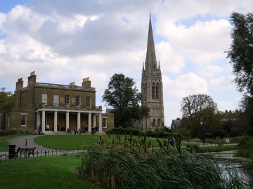 Clissold House |
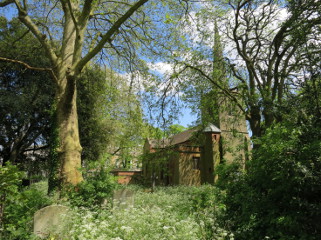 Old St Mary's Churchyard |
15. Continue forward between the house on your right (toilets here) and an adventure playground on the left, keeping left of the churchyard of St Mary's predecessor - also dedicated to St Mary - an ancient building, rebuilt 1563 and enlarged subsequently. Both churches are still in use. Turn right on a dog-leg path though the churchyard between old St Mary's and the former town hall to emerge onto Stoke Newington Church Street, then turn left.
The newer St Mary's has an impressive interior and is well worth a visit if time permits. The winding Church Street has a number of fine buildings and no shortage of pubs and places to eat. The best buildings are on the south (right-hand) side. In particular, note Sisters Place, built 1714 and Sweetapple House, both opposite Edwards Lane. Further along, Nos 135-137, set back from the road, were built in 1769. Further still, the frontage above No 113 carries an extensive painted advertisement for the repair of fountain pens.
16. After 500 metres from the churches, (soon after crossing Bouverie Road), turn left into Abney Park Cemetery. Take the forward path to arrive at the tomb of William and Catherine Booth, the founders of the Salvation Army. Other Salvation Army notables are buried nearby.
Abney Park Cemetery is one of the "Seven Magnificent Cemeteries" established as an answer to overcrowded and insanitary parish churchyards. The earliest is Kensal Green, established in 1827; the others are Highgate, West Brompton, Nunhead, West Norwood and Tower Hamlets. Abney Park dates from 1840 and, unlike many other cemeteries, was founded on unconsecrated ground. Stoke Newington had a long tradition of religious nonconformity and many of its adherents were buried there. By the time Abney Park ceased regular interments in the 1970's, nearly 200,000 burials had taken place.
17. Turn left and stay on the main path, lines of monuments receding into thick woodland. After 160 metres, at a path junction on the right, look for the monument depicting an almost life-sized lion. This commemorates Frank Bostock, a menagerist who was born in Darlington in 1866, becoming famous for touring the United States with a troupe of lions and other large cats. Notwithstanding his dangerous profession, in which he was attacked more than once, he died of influenza on a visit to England in 1912, aged only 46.
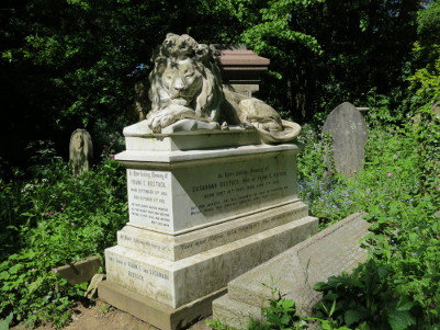
Bostock Tomb
18. Continue for another 50 metres, then turn right towards the chapel, passing to its right. When level with the chapel entrance, turn right past the War Memorial to see the monument to the prolific hymn writer, Isaac Watts. This is the largest monument in the cemetery, although Watts himself died in 1748, some ninety years before Abney Park was established, and is buried in Bunhill Fields. Return to the War Memorial and, on reaching its back, turn right on the cross-path. Follow this all the way to the Egyptian-style entrance gates and emerge onto Stamford Hill. Turn left here for 180 metres, using the pedestrian crossing to reach Stoke Newington Rail Station, from where trains run to Liverpool Street and Enfield Town.
© Mike Biggs, Ramblers (Inner London Area), 2022.
If you have any comments about this walk, or notice that it needs updating to take account of changes on the route, then please contact Mike at